


Burlington Twp. Voting District, Becker County, Minnesota
About
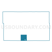
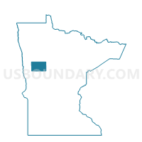
Outline

Summary
| Unique Area Identifier | 601079 |
| Name | Burlington Twp. Voting District |
| County | Becker County |
| State | Minnesota |
| Area (square miles) | 35.35 |
| Land Area (square miles) | 33.21 |
| Water Area (square miles) | 2.14 |
| % of Land Area | 93.94 |
| % of Water Area | 6.06 |
| Latitude of the Internal Point | 46.76210950 |
| Longtitude of the Internal Point | -95.74249770 |
Maps

Graphs
Select a template below for downloading or customizing gragh for Burlington Twp. Voting District, Becker County, Minnesota


Neighbors
Neighoring Voting District (by Name) Neighboring Voting District on the Map
- Candor Twp. Voting District, Otter Tail County, MN
- Detroit Lakes W-2 P-1, Becker County, MN
- Detroit Lakes W-3 P-1, Becker County, MN
- Detroit Twp. Voting District, Becker County, MN
- Erie Twp. Voting District, Becker County, MN
- Frazee Voting District, Becker County, MN
- Gorman Twp. Voting District, Otter Tail County, MN
- Height Of Land Twp. Voting District, Becker County, MN
- Hobart Twp. Voting District, Otter Tail County, MN
- Lake View Twp. Voting District, Becker County, MN
- Silver Leaf Twp. Voting District, Becker County, MN
Top 10 Neighboring County Subdivision (by Population) Neighboring County Subdivision on the Map
- Detroit Lakes city, Becker County, MN (8,569)
- Detroit township, Becker County, MN (2,033)
- Lake View township, Becker County, MN (1,685)
- Erie township, Becker County, MN (1,642)
- Burlington township, Becker County, MN (1,545)
- Frazee city, Becker County, MN (1,350)
- Hobart township, Otter Tail County, MN (778)
- Height of Land township, Becker County, MN (673)
- Candor township, Otter Tail County, MN (561)
- Silver Leaf township, Becker County, MN (534)
Top 10 Neighboring Place (by Population) Neighboring Place on the Map
Top 10 Neighboring Unified School District (by Population) Neighboring Unified School District on the Map
Top 10 Neighboring State Legislative District Lower Chamber (by Population) Neighboring State Legislative District Lower Chamber on the Map
- State House District 9B, MN (39,347)
- State House District 10B, MN (37,598)
- State House District 2A, MN (37,063)
- State House District 10A, MN (35,993)
Top 10 Neighboring State Legislative District Upper Chamber (by Population) Neighboring State Legislative District Upper Chamber on the Map
- State Senate District 9, MN (81,765)
- State Senate District 2, MN (76,807)
- State Senate District 10, MN (73,591)
Top 10 Neighboring 111th Congressional District (by Population) Neighboring 111th Congressional District on the Map
Top 10 Neighboring Census Tract (by Population) Neighboring Census Tract on the Map
- Census Tract 4503, Becker County, MN (4,962)
- Census Tract 4507, Becker County, MN (3,008)
- Census Tract 9601.02, Otter Tail County, MN (2,611)